Written by Dick Hecock ~ July 19, 2013
The sand bar separating Little and Big Detroit lakes has become a gathering place for many Lake Detroiters and others. It also serves as an important boundary between two different types of lake situations – one large and deep, the other smaller and shallow; and it figures in the two basins’ water quality differences too (a situation which I have described elsewhere).
Early descriptions of the lakes from the late 1800’s depict the sandbar as a more prominent physical boundary between the lakes than it is today. Overall the water depth over the bar was much less then, and the dry points on either end were much closer to each other. Indeed, there were at least some periods when it was possible to walk across the lake without getting wet feet.
Such walks no longer are possible, even during prolonged dry periods. Starting in the 1888 Detroit’s water levels were raised by a series of dams by the Pelican River Navigation Company. I don’t know the amount of the water level increase, but some indicate that the rise could have been between one and three feet.
I also have observed that lake levels were moved higher between 1965 and 1985 due to manipulations of the Dunton Locks dam. And since the early 1990’s precipitation has helped keep water levels high too.
Another factor contributing to a diminished prominence of the sandbar is erosion. It is quite likely that higher water levels have contributed to spreading of sandbar material into both Big and Little Detroit basins.
From the early days a channel has been cut through the sandbar to facilitate boat traffic between Big and Little Detroit. The steamships which travelled between the East shore of Big Detroit through Little Detroit, and down the Pelican River to Shoreham and beyond, required a water depth of at least two feet, so in 1888 the first channel was excavated.
The early channel was dug (and subsequently kept open) with the help of horses and mules. In most years it provided less than three feet of depth, and even as late as the early 1950’s , there are those who insist that children walked across the lake on the sandbar, and that the depth of the channel was only “about up to our waists” – so say the informants. In those days the channel was marked by a few tamarac or cedar stakes; at some point in the late 1940’s, a single light was added to assist night-time boaters in finding safe passage.
But after 1945 boats and motors grew in size, and the old channel became insufficient. There was talk about enlarging and deepening the channel, much of it by Lake Detroiters and another local organization, the “Inland Lakes Boat Club”. In the winter of 1953/54 a major dredging operation was mounted, as described in this article from the Lake Detroiters 1954 Annual Report. (Note the “membership dues” referred to were from Lake Detroiters’ members.)
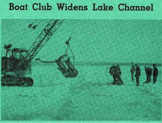
Boating enthusiasts who operate craft on Detroit Lake will welcome the news that the channel through the sand bar, which divides the two lakes, has been widened, lengthened and deepened.
The new channel is 30 feet wide, 26 feet long and six feet deep. It will accommodate passage by any boat on the lake.
The Inland Lakes Boat Club of Detroit Lakes sponsored the widening project. It was financed through donations from people who watched the club's water shows last summer and from membership dues.
The widening project was carried out by Hjalmar Brolin and Wally Schultz. A heavy dragline was used in the work.
The City of Detroit Lakes will cooperate to provide better navigation between the two lakes by placing three lights on each side of the channel. Members of the Inland Lakes Boat club will also help. In former years, only one light marked the channel.
According to President Marlowe Baxter, the club is now investigating the possibilities of extending water travel down the Pelican River to the Pelican to the State Fish Hatchery on Lake Sally.
There is some doubt that the six foot depth described in the article was actually achieved Boats continued to grow in size, weight, and draft, and in the late 1970’s and early 80’s there were new pressures to widen, deepen, and lengthen the channel. This time the Pelican River Watershed District was called upon to undertake a project to fix the channel (and to do some dredging in the Pelican River between Sallie and Melissa too). The project was greatly complicated by regulations that prohibited disposal of dredged material spoils in the lake. In the end this excavated materials from the channel were carried by barges to the Highway 10 public access where they were hauled away for disposal. The project extended over several seasons, mainly because of contractor defaults; the channel as we know it today was finally declared complete in June, 1984.